
$155.99
Add to Cart
GARMIN® GPS PORTABLE NAVIGATOR
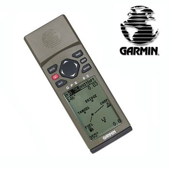
A must-have for the serious outdoor enthusiast, the Garmin® GPS-80 Portable GPS System will give you the peace of mind of knowing exactly where you are at all times.
This lightweight GPS navigator features a highly sensitive receiver that continuously tracks and uses up to 12 satellites to compute and update your exact position.
Plus, this unit includes other essentials such as an electronic compass, a barometric altimeter with elevation computer to pinpoint your precise elevation, and 500 customizable waypoints all in one compact, rugged and waterproof unit.
Features/Specifications:
Olive green color
Compact, waterproof
Ultrasonically welded, immersible to Military-Standards 81 case
2.2 x 1.5-inch black and white LCD screen with backlight display
Easy to use and understand keypad
Up to 12 hours of battery life on four AA batteries
Satellite page: Shows satellite positions and signal strength
Position page: Shows you where you are, what direction you're heading and how fast you're going
Map page: Allows you to view your position
Compass page: Gives you steering guidance
Main Menu: Access to waypoint management, route, track log and setup features
Receiver: Differential-ready PhaseTrac 12, 12-parallel channel tracks, 12 satellites continuously
Acquisition Times: Approximately: 15 sec. (warm start); 45 sec. (cold start); 5 minutes (AutoLocate)
Update Rate: 1/second, continuous
Position Accuracy: 1 - 5 meters (3-17 ft with DGPS corrections; 15 meters (49 ft.) RMS)
Velocity Accuracy: 0.1 knot RMS steady rate
Dynamic: 6g
Waypoints: Total: 500 alphanumeric
Nearest: 9 (automatic)
Proximity: 9 (with alarm)
Routes: 20 reversible with up to 30 points each, plus MOB mode
Position Formats: MGRS, UTM/UPS, British, Swiss, German, Irish, Indonesian, Indian (nine) and Malaysians grids, lat/long, user
Track Points: 1024
Map Datums: 106, plus user-defined
Antenna: Internal, with external antenna capability
Unit Dimensions: 5.74 x 2 x 1.33-inches (H x W x D) (white box pkg)
This lightweight GPS navigator features a highly sensitive receiver that continuously tracks and uses up to 12 satellites to compute and update your exact position.
Plus, this unit includes other essentials such as an electronic compass, a barometric altimeter with elevation computer to pinpoint your precise elevation, and 500 customizable waypoints all in one compact, rugged and waterproof unit.
Features/Specifications:
Olive green color
Compact, waterproof
Ultrasonically welded, immersible to Military-Standards 81 case
2.2 x 1.5-inch black and white LCD screen with backlight display
Easy to use and understand keypad
Up to 12 hours of battery life on four AA batteries
Satellite page: Shows satellite positions and signal strength
Position page: Shows you where you are, what direction you're heading and how fast you're going
Map page: Allows you to view your position
Compass page: Gives you steering guidance
Main Menu: Access to waypoint management, route, track log and setup features
Receiver: Differential-ready PhaseTrac 12, 12-parallel channel tracks, 12 satellites continuously
Acquisition Times: Approximately: 15 sec. (warm start); 45 sec. (cold start); 5 minutes (AutoLocate)
Update Rate: 1/second, continuous
Position Accuracy: 1 - 5 meters (3-17 ft with DGPS corrections; 15 meters (49 ft.) RMS)
Velocity Accuracy: 0.1 knot RMS steady rate
Dynamic: 6g
Waypoints: Total: 500 alphanumeric
Nearest: 9 (automatic)
Proximity: 9 (with alarm)
Routes: 20 reversible with up to 30 points each, plus MOB mode
Position Formats: MGRS, UTM/UPS, British, Swiss, German, Irish, Indonesian, Indian (nine) and Malaysians grids, lat/long, user
Track Points: 1024
Map Datums: 106, plus user-defined
Antenna: Internal, with external antenna capability
Unit Dimensions: 5.74 x 2 x 1.33-inches (H x W x D) (white box pkg)


